
Elementor #354
Mahuli Fort: The Highest Peak in Thane
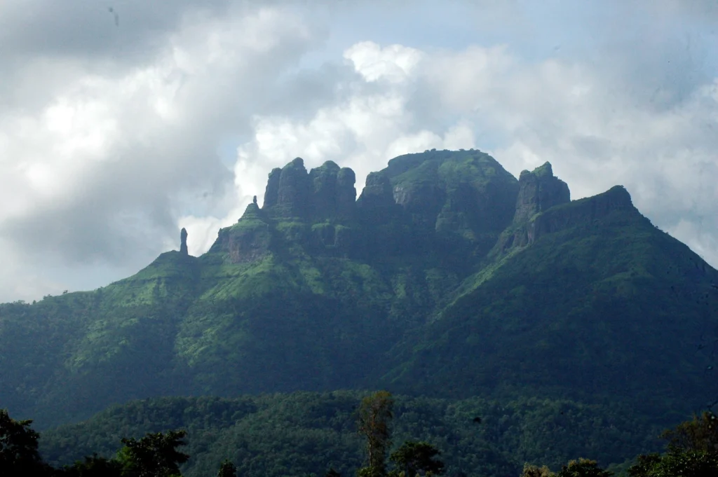
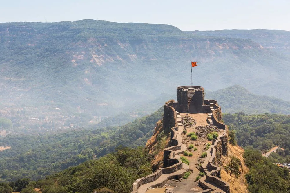
Mahuli Fort: The Highest Peak in Thane Hello, fellow explorers! If you are someone who loves a good physical challenge and wants to feel like you are standing on the roof of the world, then Mahuli Fort is the destination for you. As a local guide who has spent many mornings watching the sunrise from these peaks, I can tell you that there is nothing quite like the feeling of conquering the highest point in Thane district. This isn’t just a simple walk; it is a true trekker’s paradise filled with thick forests, ancient history, and some of the most dramatic rock formations in the Sahyadris. 1. Introduction & Location Overview Mahuli Fort is located near Asangaon in the Thane district of Maharashtra. Standing at a majestic height of about 2,815 feet, it is the highest peak in the region. The fort is actually part of a large mountain range that has three distinct peaks—Mahuli, Bhandargad, and Palasgad. When you look at the mahuli fort location from the base, the mountain looks like a giant hand with fingers pointing toward the sky. It is situated within the Tansa Wildlife Sanctuary, which means the entire climb is surrounded by rich greenery, diverse plants, and the sounds of nature. It is roughly 75 km from Mumbai and 150 km from Pune. 2. Why This Fort Is Famous This fort is famous for being a mecca for rock climbers. The vertical cliffs and “pinnacles” (sharp rock peaks) of Mahuli are legendary. Professionals come from all over India to test their skills on these natural stone walls. For regular trekkers, it is famous for the Mahuli Fort Shiva Temple and the large open caves that can shelter dozens of people at once. It is also well-known for its deep connection to the history of the Maratha Empire. In the monsoon, it becomes even more famous because the entire mountain gets covered in waterfalls, making it look like a scene from a fantasy movie. 3. Detailed History of the Fort The mahuli fort history is one of constant battles and shifting power. Mughal and Nizam Era: The fort was originally part of the Nizam Shahi dynasty of Ahmednagar. It was considered an impenetrable stronghold because of its height. Shahaji Maharaj’s Brave Stand: In 1635-36, Shahaji Maharaj (the father of Chhatrapati Shivaji Maharaj) took shelter here with a young Shivaji while being chased by the massive Mughal and Adilshahi armies. This makes the fort very significant in the story of the birth of the Maratha Empire. The Maratha Conquest: Shivaji Maharaj captured the fort in 1658. However, like many other forts, it was surrendered to the Mughals under the Treaty of Purandar in 1665. Winning it Back: The Marathas eventually won it back in 1670, and it remained an important lookout point until the British took control in 1818. 4. Architecture & Strategic Importance The architecture of Mahuli is unique because it uses the natural rock as its main defense. The Pinnacles: These act as natural watchtowers. In the old days, guards could see all the way to the Arabian Sea and the city of Kalyan. Rock-cut Steps: To reach the higher sections, you have to climb steps carved directly into the mountain stone. Caves: The fort has massive natural caves that were expanded by humans to store grains and ammunition. These caves are still in excellent condition. Strategic Gate: The main entrance is hidden between rocks, making it very difficult for an enemy to use a battering ram or elephants to break in. 5. How to Reach the Fort Reaching Mahuli is very convenient for those using public transport: By Train: This is the most popular way. Take a Central Line local train to Asangaon Railway Station. From the station, you can hire a private rickshaw to the base village, which is about 5 km away. By Road: If you are driving from Mumbai, take the Mumbai-Nashik highway (NH3). After crossing the Khadavli and Vasind regions, you will reach Asangaon. Take a left turn toward the Mahuli village. By Bus: ST buses from Kalyan or Thane go toward Shahapur; you can get down at Asangaon and take a local rickshaw. Trek Routes: The trek starts from the Mahuli village, right next to a small forest check-post. 6. Trek Information The Mahuli fort trek is a rewarding experience but requires some stamina. Difficulty: Moderate. It is a continuous climb with some steep sections and a few small rock patches. Duration: It takes about 2.5 to 3 hours to reach the top from the base village. Mahuli Fort Trek Distance: The total distance is about 5 km one way. Route: The trail goes through a dense forest, crosses a small stream, and then follows a zig-zag path up the mountain. 7. Entry Fees, Timings & Permissions Entry Fee: Since it is part of a wildlife sanctuary, there is a small forest entry fee (approx. ₹20-₹30 per person) collected at the base. Timings: Open from 6:00 AM to 6:00 PM. Night trekking is officially not allowed without special permission from the forest department. Parking: Ample parking space is available at the base village for a small fee. 8. Best Time to Visit Monsoon (June to September): The most beautiful time. The waterfalls are in full flow, and the forest is lush green. However, be careful as the path can be slippery. Winter (October to February): The best time for the views. The air is cool, and the sky is clear, allowing you to see the distant peaks of the Sahyadris. Summer: Only recommended for early morning treks, as the forest can get very humid. 9. Things to See on the Fort Shiva Temple: A small, ancient temple at the top where trekkers often offer prayers. The Big Cave: A massive cave that can easily accommodate 50 people. It’s a great spot for a lunch break. The Three Peaks: Explore the different plateaus of Mahuli, Bhandargad, and Palasgad. Kalyan Darwaja: An old gateway that offers a view toward
Peb Fort (Vikatgad): The Matheran Lookout Trek

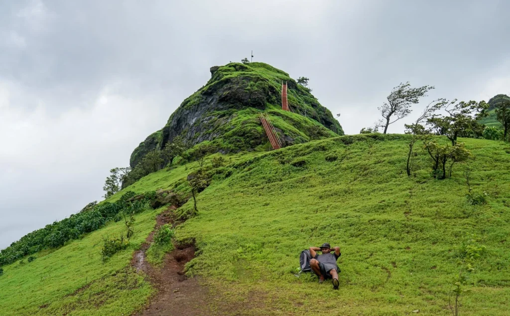
Peb Fort (Vikatgad): The Matheran Lookout Trek Welcome back, adventure lovers! If you have ever been to Matheran and looked across at the sharp mountain ridges, you were likely looking at Peb Fort. Also known as Vikatgad, this fort is a hidden treasure for people who love trekking. It is unique because it is one of the few places where you can combine a rugged mountain climb with a walk along the famous Matheran toy train tracks. If you want a trek that feels like a real journey through the clouds, Peb Fort is the place for you. 1. Introduction & Location Overview Peb Fort is located near Neral in the Karjat region of Maharashtra. It is part of the same mountain range as the famous Matheran hill station. The fort stands at an elevation of about 2,100 feet. The peb fort is named after the Goddess Pebi, whose temple is located at the base. It is also called Vikatgad because the peak of the mountain is shaped like the head of Lord Ganesha (Vikat). Its location is very strategic because it sits right between the busy plains of Neral and the high plateau of Matheran. 2. Why This Fort Is Famous This fort is famous for its incredible ridge walk. Unlike other forts where you just climb up a hill, at Peb, you walk along narrow mountain ridges that give you a “top of the world” feeling. It is also famous for its connection to Matheran. Most trekkers finish the climb at the fort and then continue walking to reach the Matheran railway tracks. This makes it a “two-in-one” adventure! Additionally, the fort is known for its beautiful meditation chambers and the 360-degree views of the entire Karjat and Malanggad range. 3. Detailed History of the Fort The history of Peb Fort is closely tied to the defense of the Konkan region. A Military Watchtower: During the 17th century, the fort was used as a watchtower by the Maratha Empire. Because it overlooks the entire valley toward Mumbai and Kalyan, it was the perfect place to spot enemy movements. Storage Hub: It was also used to store grain (Silo) for the army stationed in the nearby regions. Shivaji Maharaj’s Era: It is believed that Chhatrapati Shivaji Maharaj used this fort as a transit point. The caves on the fort provided a safe place for soldiers to rest during long travels between Raigad and the northern forts. 4. Architecture & Strategic Importance The architecture of Peb is simple but very clever. The Caves: There are several large caves on the fort. Some were used for storage, while others are now used as meditation centers by monks and travelers. Rock-cut Steps: The ancient builders carved steps directly into the steep rock faces to make the climb possible for soldiers. Bastions: There are several bastions (Buruj) that are still in good condition, offering views of the surrounding valleys. Strategic Location: Its height allowed soldiers to send signals to other forts like Haji Malang and Chanderi using fire or mirrors. 5. How to Reach the Fort Reaching the peb fort vikatgad trek base point is very easy for Mumbaikars: By Train: Take a local train to Neral Station (Central Line). By Bus/Taxi: From Neral station, you can take a shared taxi toward Matheran. Ask the driver to drop you at the “Peb Fort starting point” (near the railway track gate). By Road: If driving, go toward Neral and take the Matheran hill road. You can park near the Dasturi Naka or at the specific start point on the hill road. The Route: There are two main ways to reach: From Anandwadi village (steep climb). From the Matheran Toy Train tracks (easier and more popular). 6. Trek Information The peb fort trek is exciting and varies in difficulty. Difficulty: Moderate. There are some narrow patches and a few ladders to climb. Duration: It takes about 2.5 to 3 hours to reach the summit from Neral. Peb Fort Trek Distance: The total walk is about 4 to 5 km if you go all the way to Matheran. Route Experience: You will pass through forests, climb iron ladders, walk along a ridge, and finally reach the temple at the top. 7. Entry Fees, Timings & Permissions Entry Fee: There is no entry fee for the fort. Timings: Open all day. However, it is highly recommended to start by 7:30 AM so you reach Matheran by lunchtime. Permissions: No special permits are required. 8. Best Time to Visit Monsoon (July to September): The best time to visit for greenery and waterfalls. The ridge walk feels like walking through the clouds. Winter (October to February): The weather is cool and clear. You can see very far into the horizon, making it great for photography. Summer: Avoid the peak summer heat as the ridge walk is very open to the sun. 9. Things to See on the Fort The Temple of Goddess Pebi: A peaceful spot at the summit. Meditation Caves: Beautifully maintained caves where you can sit in silence. The Ladders: Iron ladders fixed to the rock that add a touch of adventure. The Ridge: A narrow path with deep valleys on both sides (very scenic!). Shivaji Maharaj’s Footprints: A symbolic stone carving at the top. 10. Things to Do Near the Fort Matheran Hill Station: Explore the market, viewpoints, and horse riding in Matheran after your trek. Toy Train Ride: If the train is running, you can catch it from Aman Lodge to Matheran. Neral Village: Try local snacks and explore the foothills. 11. Safety Risks & Dangerous Areas Narrow Ridges: Some parts of the trail are very narrow. Be careful, especially if it is windy. Slippery Rocks: In the monsoon, the rocky patches can be very slippery. Ladders: Ensure you have a firm grip on the iron ladders. Only one person should climb at a time. 12. Safety Precautions Avoid Selfies on Edges: The valleys are very deep. Keep your phone away while walking on
Sondai Fort: The Best Monsoon Secret of Karjat
Sondai Fort: The Best Monsoon Secret of Karjat Hello friends! If you are looking for a trek that is short, exciting, and feels like you are walking through a giant green carpet, then you must visit Sondai Fort. Located near Karjat, this is not a massive military fort like Raigad, but it was a very important watchtower in the old days. Today, it is a favorite for people who want a quick escape from Mumbai or Pune without spending the whole day climbing. 1. Introduction & Location Overview Sondai Fort is situated in the Karjat taluka of Raigad district. It stands at a height of about 1,200 feet above sea level. While that might sound small compared to other mountains, the view from the top is absolutely grand. The fort is named after the goddess Sondai Devi, whose small shrine sits right at the very peak. The base village is called Sondewadi. The location is very convenient because it is close to the Karjat railway station, making it a popular choice for college students and weekend travelers. 2. Why This Fort Is Famous Sondai is famous for its stunning view of the Morbe Dam. From the top, you can see the massive blue waters of the dam spread out like a giant mirror. On a clear day, you can also spot other famous peaks like Matheran, Prabalgad, and Irshalgad from the summit. Another thing that makes it famous is the iron ladders. To reach the final pinnacle, you have to climb a set of sturdy iron ladders fixed to the rock. It adds a little bit of thrill to an otherwise easy trek! It is also known as one of the best “beginner treks” because even if you have never trekked before, you can easily reach the top. 3. Detailed History of the Fort The history of Sondai is more about trade than big wars. The Watchtower: In the 17th century, during the time of the Maratha Empire, Sondai was used as a watchtower. Its job was to keep an eye on the trade routes coming from the Konkan toward the Bhor Ghat. The Village Legend: Local villagers believe that the goddess Sondai Devi has protected their homes for centuries. Many people from nearby villages climb the fort even today to offer prayers, especially during local festivals. Strategic Role: Because it is located right next to the path leading to Matheran, it helped soldiers spot any enemy movements early and send signals to the larger forts nearby. 4. Architecture & Strategic Importance Since it was a watchtower, the architecture of Sondai is very simple. The Pinnacle: The fort is basically a rocky peak with a flat area at the base of the pinnacle. Rock-cut Cisterns: There are several water tanks carved directly into the rock. These were used to store rainwater for the guards stationed there. The Ladders: Originally, there were rock-cut steps, but over time they wore away. Now, the government and local groups have installed iron ladders to make it safe for everyone. 5. How to Reach the Fort Reaching Sondai is very easy from the city: By Train: Take a local train to Karjat Station. From Karjat (East), you can take a shared rickshaw or a “Tum-Tum” to the base village, Sondewadi. By Road: If you are driving from Mumbai, head toward Karjat via the Chowk-Phata road. The distance from Mumbai is about 70 km, and from Pune, it is about 100 km. By Bus: You can take a bus to Karjat and then use local transport to reach the village. Trek Routes: The path starts from Sondewadi village. It is a well-beaten track that goes through small farms and then up the hill. 6. Trek Information The Sondai trek is short and sweet! Difficulty: Easy. It is perfect for families and first-time trekkers. Duration: It takes only about 1 to 1.5 hours to reach the top. Route: The first 30 minutes are a walk through the forest. The last 20 minutes involve climbing the iron ladders and a few rocky steps. 7. Entry Fees, Timings & Permissions Entry Fee: There is no entry fee to visit the fort. Timings: Open all day, but it is best to visit between 7:00 AM and 5:00 PM. Permissions: You do not need any special permission to trek here. 8. Best Time to Visit Monsoon (June to September): This is the best time to visit. The hill is covered in mist, there are tiny waterfalls everywhere, and the Morbe Dam looks beautiful in the rain. Winter (October to February): The air is cool and the views are very clear. It’s great for a sunny Sunday outing. 9. Things to See on the Fort Sondai Devi Idol: A small orange-painted idol of the goddess at the very top. Water Tanks: Ancient rock-cut tanks that are usually full of water in the monsoon. Morbe Dam View: The highlight of the trek! The Iron Ladders: A fun part of the climb that makes for great photos. 10. Things to Do Near the Fort Morbe Dam: You can drive to the edge of the dam for a relaxing evening. NND Solanpada Dam: Another beautiful dam near Karjat where you can enjoy the water. Karjat Farmhouses: Many people stay in local farmhouses nearby for a weekend stay. 11. Safety Risks & Dangerous Areas Slippery Ladders: During the monsoon, the iron ladders can be a bit slippery. Hold the railings firmly. Beehives: Sometimes there are large beehives on the rock faces. Do not make loud noises or throw stones near them. Narrow Top: The space at the very top near the idol is small. Be careful not to push others while taking photos. 12. Safety Precautions Wear Good Shoes: Even though it’s an easy trek, the mud can be slippery in the rains. Don’t Rush: Take your time on the ladders. One person should climb at a time. Stay Hydrated: Carry water even if it’s a short trek. 13. Things to Carry Before Visiting Water:
Korigad Fort: The Giant Plateau of Lonavala
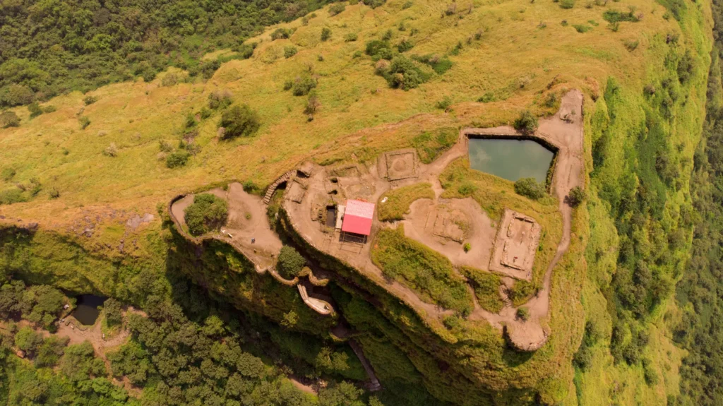
Korigad Fort: The Giant Plateau of Lonavala Hello friends! Today, we are heading to the popular hill station of Lonavala. But we aren’t just going to see the waterfalls or eat chikki; we are climbing the magnificent Korigad Fort. If you are looking for a trek that is easy on the legs but offers a massive area to explore at the top, Korigad is perfect for you. It is one of the few forts in Maharashtra that is still in very good condition, and its wide plateau feels like a big natural playground in the sky. 1. Introduction & Location Overview Korigad (also called Koraigad) is a hill fort located about 20 km from Lonavala in the Pune district. It stands at an elevation of about 3,028 feet. What makes the location very interesting is that it sits right next to the planned hill city of Aamby Valley. When you stand at the top of the fort, you can see the luxury villas and airstrip of Aamby Valley on one side and the wild, green Sahyadri mountains on the other. It is a strange but beautiful mix of modern life and ancient history. 2. Why This Fort Is Famous Korigad is famous for its massive plateau. Unlike many other forts that have narrow peaks, the top of Korigad is a huge flat land. You can walk along the entire boundary wall of the fort, which is about 2 kilometers long and almost completely intact. It is also famous for its six large cannons. One of them, called the “Laxmi Toph,” is particularly famous because it is the largest one on the fort and is still in great shape. For many trekkers, Korigad is the favorite choice for a “rainy day trek” because the path is clear and the view of the surrounding clouds is magical. 3. Detailed History of the Fort The history of Korigad dates back several centuries, but it became very important during the Maratha Empire. Shivaji Maharaj’s Era: This fort was incorporated into the Maratha Kingdom in 1657 by Chhatrapati Shivaji Maharaj, along with other forts like Lohagad and Visapur. The British Invasion: In March 1818, the British army attacked the fort. They had a hard time because the fort’s walls were so strong. However, a lucky (or unlucky) cannonball from the British side hit the fort’s ammunition store, causing a massive explosion. This forced the Marathas to surrender. Local Legend: There is a temple of Koraidevi on the fort, and locals believe the goddess protects the region. The fort is named after her. 4. Architecture & Strategic Importance Korigad is a masterpiece of defense architecture. The Massive Walls: The most impressive part of the fort is its boundary walls. They are wide enough for two or three people to walk side-by-side. Entrance Gates: The fort has two main gates (Ganesh Darwaja and the main entrance) which are still standing strong. Water Ponds: There are two large permanent ponds at the top. Even in the middle of summer, these ponds usually have water, which was a vital strategic advantage during long sieges. Strategic View: From the top, soldiers could keep an eye on the Konkan and Maval regions simultaneously. 5. How to Reach the Fort Reaching Korigad is a very scenic drive: By Train: Take a local train to Lonavala Station. From the station, you can hire a private taxi or take a bus toward Aamby Valley. By Road: If you are driving from Mumbai or Pune, head toward Lonavala. Take the road leading to Aamby Valley. The base village is called Peth Shahpur. Distance: It is about 100 km from Mumbai and 90 km from Pune. Trek Routes: The trek starts directly from Peth Shahpur village. There is a well-paved path and stone steps for most of the way. 6. Trek Information The Korigad trek is one of the easiest treks near Lonavala. Difficulty: Easy. It is perfect for beginners, children, and even elder people who are active. Duration: It takes only 45 minutes to 1 hour to reach the top from the base village. Route: The path goes through a small forest and then turns into a long flight of stone steps. 7. Entry Fees, Timings & Permissions Entry Fee: There is no entry fee for the fort. Timings: Open from 6:00 AM to 6:00 PM. Parking: You can park your car or bike in Peth Shahpur village for a small fee (₹20-₹50). 8. Best Time to Visit Monsoon (June to September): This is the best time to visit. The fort is covered in mist, and the plateau becomes a carpet of green grass and wild flowers. Winter (October to February): The weather is pleasant and clear, perfect for walking the long boundary walls. 9. Things to See on the Fort Laxmi Toph: The biggest cannon on the fort, located near the temple. Koraidevi Temple: A small but beautiful temple that was recently renovated. The Two Lakes: Perfect spots to sit and enjoy the cool breeze. The Boundary Wall: Walking the full circle of the fort is a must-do. Ganesh Darwaja: Look for the beautiful carvings of Lord Ganesha on the entrance gate. 10. Things to Do Near the Fort Aamby Valley City: You can view the grand city from the fort or drive to its entrance nearby. Lion’s Point & Tiger’s Point: Famous sunset spots in Lonavala located on the way back. Bhushi Dam: A popular spot to enjoy the water during monsoons. 11. Safety Risks & Dangerous Areas Slippery Steps: During the monsoon, the stone steps can get covered in moss and become very slippery. The Edges: While the plateau is wide, some parts of the boundary wall are broken. Be careful when taking photos near the edge. Wind: It can get very windy on the plateau, which can sometimes make you lose your balance if you are standing on the wall. 12. Safety Precautions Footwear: Wear shoes with a good rubber grip. Stay on the Path: Don’t try to climb the
Murud-Janjira: The Unconquered Marine Marvel
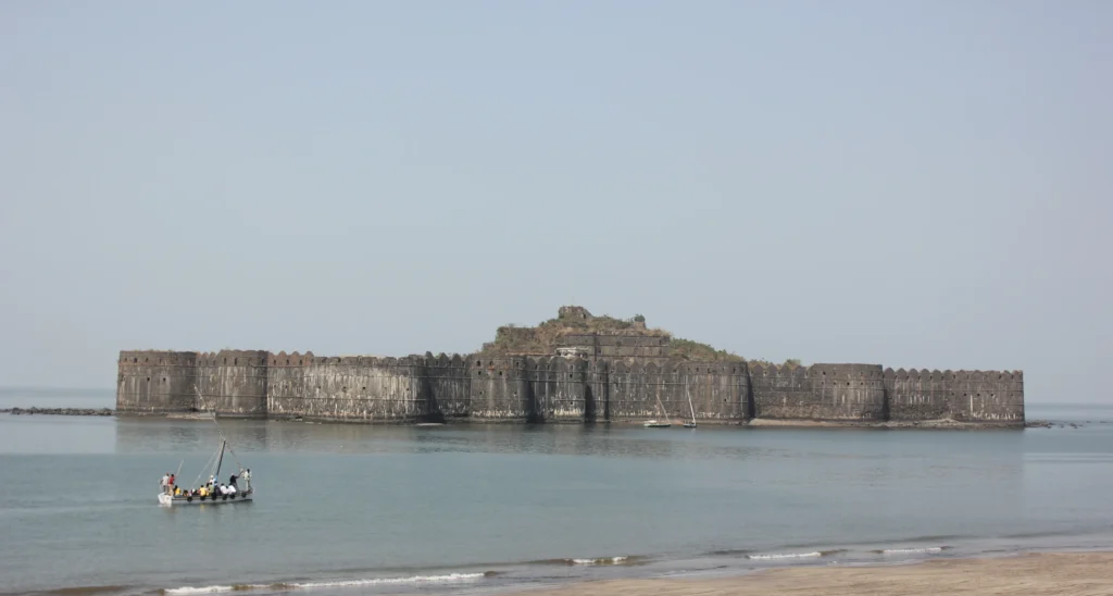
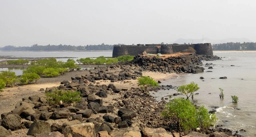
Murud-Janjira: The Unconquered Marine Marvel Welcome back to our journey through Maharashtra’s glorious past! Today, we are visiting a place that many call the “invincible” fort. If you have ever wanted to see a massive stone castle that floats in the middle of the deep blue Arabian Sea, then Murud-Janjira is the place for you. This fort is legendary because, for hundreds of years, many powerful kings tried to capture it, but none succeeded. It remained “unconquered” until the very end. 1. Introduction & Location Overview Murud-Janjira is a spectacular sea fort located off the coast of Murud village in the Raigad district. Often referred to by tourists as the janjira fort alibag, it is actually situated about 55 kilometers south of Alibaug. The fort is built on an oval-shaped rock in the sea. To get there, you have to leave the mainland behind and take a boat from the Rajapuri jetty. As you sail closer, the massive 40-foot-high walls seem to rise directly out of the waves. It is easily one of the most impressive forts in Maharashtra and a must-visit for anyone traveling to the Konkan coast. 2. Why This Fort Is Famous This fort is world-famous because it is one of the very few coastal strongholds in India that was never captured in a battle. Even the great Maratha Navy, the Mughals, and the British could not break its defenses. It is also famous for its incredible architecture. The main gate is hidden so cleverly that you can only see it when your boat is just a few meters away. Inside, despite being surrounded by salty seawater, the fort has two large natural lakes that provide fresh, sweet drinking water. Additionally, it houses three of the largest cannons in India, which were used to keep enemy ships far away from the shore. 3. Detailed History of the Fort The history of Murud-Janjira is like an action movie. The Siddis: The fort was the stronghold of the Siddis, people of African descent who came to India as traders and soldiers. They became so powerful that they established their own independent state here. The Wooden Beginnings: Originally, in the 15th century, it was just a small wooden structure built by local fishermen to protect themselves from pirates. The Siddis captured it and turned it into the stone giant we see today. Maratha Attacks: Chhatrapati Shivaji Maharaj tried to capture this fort multiple times. His son, Sambhaji Maharaj, even tried to build a secret undersea tunnel and a nearby fort (Padmadurg) to defeat the Siddis, but Janjira stood firm. The Name: The word “Janjira” comes from the Arabic word Jazeera, which means “island.” 4. Architecture & Strategic Importance The architecture of Murud-Janjira is a masterpiece of maritime defense. Invisible Gates: The “Sher Darwaza” (Main Gate) is built into a curve of the wall, making it invisible from a distance. This prevented enemies from targeting the gate with cannons from their ships. Strong Walls: The fort has 21 rounded bastions that are still in excellent condition. These allowed guards to fire in every direction. The Cannons: The most famous cannon is called Kalal Bangadi. It was made by joining iron rings together and had a range so long that it could sink ships before they even got close to the island. Emergency Exit: There is a secret “Darya Darwaza” (Sea Gate) at the back of the fort that opens directly into the deep sea, used for escapes or receiving supplies during a siege. 5. How to Reach the Fort Reaching the fort is a two-step adventure: By Road: You can drive from alibaug to murud janjira via the scenic Revdanda-Kashid road. It takes about 2 to 2.5 hours from Alibaug. If you are coming from Mumbai, it is about 150 km. By Bus: Regular ST buses run from Alibaug and Mumbai to the Murud bus depot. The Boat Ride: Once you reach the alibaug murud area, you must go to the Rajapuri Jetty. From here, you board a traditional sailboat. The boatmen use the wind to guide the boat to the fort entrance, which is a thrilling experience! 6. Trek Information Since this is a sea fort, there is no mountain climbing, but there is plenty of walking involved. Difficulty: Easy. However, you must be able to climb a few steps from the boat into the fort entrance. Duration: The boat ride takes 15-20 minutes, and you usually get about 1 to 1.5 hours to explore the fort before the boat takes you back. Routes: There is only one way in and out—via the main sea gate. 7. Entry Fees, Timings & Permissions Entry Fee: There is no fee for the fort itself, but you have to pay for the boat ride (approx. ₹80–₹100 per person). Timings: 7:00 AM to 6:00 PM. Important Note: The fort is closed during the monsoon season (June to September) because the sea is too rough for the small boats to operate. Friday Break: The fort often closes for a couple of hours on Friday afternoons between 12:00 PM and 2:00 PM for prayers. 8. Best Time to Visit Winter (October to March): This is the alibag murud janjira peak season. The weather is cool, and the boat ride is very smooth. Summer: It can be very hot on the island with no shade, so visit early in the morning. 9. Things to See on the Fort The Giant Cannons: Specifically Kalal Bangadi, Landa Kasam, and Chavri. They are made of a special 5-metal alloy that doesn’t get hot even in the sun. The Freshwater Lakes: It is amazing to see deep pools of sweet water in the middle of the salty ocean. The Palace Ruins: You can see the remains of the 5-story palace where the Nawabs once lived. The Mosque: A small, beautiful prayer hall that is still used occasionally. The View: Climb the highest point (the Citadel) for a breathtaking view of the ocean and the distant Padmadurg fort. 10. Things to
Korlai Fort: The Lighthouse Guardian of Revdanda
Korlai Fort: The Lighthouse Guardian of Revdanda Welcome back to our exploration of the coastal wonders of Maharashtra! Today, we are visiting a place that feels like a slice of Portugal hidden on the Konkan coast. We are heading to Korlai Fort, a magnificent maritime structure that stands at the mouth of the Kundalika River. If you love the combination of blue seas, white-sand beaches, and ancient ruins, then korlai fort is a destination you must add to your bucket list. Lorem ipsum dolor sit amet, consectetur adipiscing elit. Ut elit tellus, luctus nec ullamcorper mattis, pulvinar dapibus leo. 1. Introduction & Location Overview Korlai Fort is a coastal fortress located near the village of Korlai in the Raigad district. It is situated about 22 kilometers from the main Alibaug town and just a few kilometers across the bridge from Revdanda. What makes the korlai fort location so special is its geography. The fort is built on a narrow ridge of a hill that jutts out into the Arabian Sea, surrounded by water on three sides. From a distance, it looks like a giant stone ship anchored at the edge of the land. It is one of the most picturesque forts near Alibaug because it perfectly bridges the gap between a hill fort and a sea fort. 2. Why This Fort Is Famous There are three main reasons why travelers flock to this spot. First is the Korlai Fort Lighthouse. This tall, vibrant lighthouse is still fully functional and is one of the few places where you can get a guided tour of how maritime navigation works. Second, it is famous for the Korlai Portuguese Creole. The villagers living at the base of the fort speak a unique language called “Kristi,” which is a blend of Portuguese and Marathi. It is the only place in India where this specific dialect is spoken! Third, the fort is famous for its “No Entry Without a Fight” inscription. At the main entrance, there is an ancient stone carving that warned enemies that they could not pass the gates without a battle. Today, it serves as a legendary reminder of the fort’s fierce past. 3. Detailed History of the Fort The korlai fort history is a fascinating tale of colonial ambition and local bravery. Portuguese Origins: The fort was built in 1521 by the Portuguese with the initial permission of the Ahmednagar Sultanate. They named it “Morro de Chaul.” The Great Siege: In 1594, a massive battle took place where the Portuguese officially took full control of the ridge. Legend says the defenders even used a dead elephant to block the main gate! Maratha Conquest: Despite its strength, the great Maratha warriors were always eyeing this strategic point. It finally came under Maratha rule in 1739 during the campaign led by Chimaji Appa. British Era: Like many other strongholds, it was eventually taken by the British in 1818. 4. Architecture & Strategic Importance The architecture of korlai fort is a brilliant example of European military design adapted for Indian shores. Long and Narrow: The fort is nearly 2,800 feet long but very narrow, following the shape of the hill ridge. Seven Gates: It features eleven gates in total (four outer and seven inner), each designed to trap invaders in narrow passages. The Church of St. Matthew: One of the most beautiful sights inside is the ruins of an old Portuguese church. Although the roof is gone, the arched windows provide a “photo frame” view of the blue ocean. Strategic Vantage: Because it sits at the mouth of the Revdanda Creek, the fort could control every single ship entering or leaving the important trading port of Chaul. 5. How to Reach the Fort Reaching korlai fort is a scenic journey: By Road: You can drive from Alibaug (22 km) toward Murud-Janjira. Once you cross the Revdanda Bridge, look for the sign for Korlai village. By Bus: Take a state transport (ST) bus from Alibaug toward Murud and get down at the Korlai bus stop. By Ferry: Take the ferry from Mumbai (Gateway of India) to Mandwa. From Mandwa, you can take a bus or hire a rickshaw to reach Korlai. The Final Stretch: There is a narrow motorable road that leads right up to the korlai fort lighthouse. However, the road is very slim, so many people prefer to park in the village and walk up. 6. Trek Information The korlai fort trek is more of a pleasant walk than a difficult hike. Difficulty: Very Easy. It is suitable for children and senior citizens. Duration: It takes only 15 to 20 minutes to reach the main fortifications from the lighthouse base. Routes: The most popular route is the flight of stairs starting from behind the lighthouse. There is also a jungle trail from the village side, but the lighthouse route is much easier to find. 7. Entry Fees, Timings & Permissions Entry Fee: There is typically no entry fee for the fort itself. However, the Korlai Fort Lighthouse has a small fee (approx. ₹10–₹20) if you wish to go inside. Timings: The fort is open from 6:00 AM to 6:00 PM. Lighthouse Hours: The lighthouse usually allows visitors only between 4:00 PM and 6:00 PM. Plan your trip accordingly if you want to see the view from the top of the tower! 8. Best Time to Visit Winter (October to March): The korlai fort best time to visit is during the cool months. The weather is perfect for exploring the ruins without getting tired. Monsoon (June to September): The hill turns incredibly green, and the sea looks powerful and majestic. However, be careful as the steps can get slippery. Summer: Avoid the midday sun; visit either at sunrise or sunset. 9. Things to See on the Fort The Lighthouse: A modern marvel with a 360-degree view. The Ruined Church: Perfect for korlai fort photos and quiet reflection. Ancient Cannons: You can still find several iron cannons resting on the bastions. Portuguese Inscriptions: Look for
Kolaba Fort: The Stone Guardian of Alibaug
Kolaba Fort: The Stone Guardian of Alibaug Welcome back to our tour of Maharashtra’s grand history! Today, we are swapping the high mountain peaks for the salty breeze of the Arabian Sea. We are visiting Kolaba Fort, also known simply as the Alibag fort. This is not your typical fort; it is a sea fort that plays a game of hide-and-seek with the tides. If you want to experience the feeling of walking through the ocean to reach a massive stone castle, then kolaba fort alibaug is a place you cannot miss. Kolaba Fort is located right in the middle of the sea, about 1 to 2 kilometers off the shores of Alibaug in the Konkan region. While many people confuse it with the “Colaba” area in Mumbai, this kolaba is the heart and soul of Alibaug’s coastline. The location is unique because the fort is built on a small island that becomes accessible by foot only during low tide. It is the most famous of the forts in alibaug and is a major landmark that you can see clearly from the main alibaug beach fort area. 2. Why This Fort Is Famous This fort is famous because it is a “walking fort.” During low tide, the water recedes, and a sandy path appears, allowing tourists to walk or take a horse-cart directly from colaba beach alibaug to the fort gates. When the high tide comes, the path disappears under several feet of water, and the fort becomes a lonely island again. It is also famous for its incredible Maratha architecture. Despite being surrounded by the salty Arabian Sea for over 300 years, the fort still stands strong. Another mystery that makes it famous is its freshwater wells; even though it is in the middle of the ocean, the water inside the fort is sweet and drinkable! 3. Detailed History of the Fort The history of this fort is filled with stories of the brave Maratha navy. Shivaji Maharaj’s Vision: Chhatrapati Shivaji Maharaj chose this site in 1662 to build a naval base that could keep an eye on the British, Portuguese, and the Siddis of Janjira. The Golden Era: The fort became the main headquarters of the Maratha Navy under the command of the legendary Admiral Kanhoji Angre. He was so powerful that even the European navies were afraid of him. Resisting Invasions: The British and Portuguese attacked the fort many times, but they could never capture it in a direct battle. It remained a strong shield for the Konkan coast for a very long time. 4. Architecture & Strategic Importance The architecture of kolaba fort is designed to withstand both enemy cannons and the crashing waves of the sea. The Walls: The fort walls are about 25 feet high and are made of heavy black stone. Strategic Gates: There are two main gates. One faces Alibaug (the Mahadarwaja) and the other faces the open sea (Darya Darwaza). Sweet Water Wells: The internal freshwater tanks are a marvel of ancient engineering, ensuring that the soldiers never went thirsty even during long sea blockades. Security: From the bastions, soldiers could spot enemy ships from a great distance, making it impossible for anyone to sneak up on the Alibaug coast. 5. How to Reach the Fort Reaching the fort is an adventure in itself: By Road: Alibaug is well-connected to Mumbai (100 km) and Pune (150 km). You can drive down or take a direct bus to the Alibaug bus depot. By Ferry: The most scenic way is to take a ferry from the Gateway of India or Bhaucha Dhakka in Mumbai to Mandwa Jetty, then a bus to Alibaug. Reaching the Island: Once you reach colaba beach alibaug, you have two choices depending on the tide: Low Tide: You can walk the 1-2 km distance through the wet sand and shallow water. Horse Cart: For a small fee, you can enjoy a ride on a horse-drawn carriage that takes you across the seabed. Boat: During medium tides, small boats sometimes operate, but usually, the fort is closed during high tide for safety. 6. Trek Information Since this is a sea fort, there is no “mountain climbing” involved. Difficulty: Very Easy. It is a flat walk on the sand. Duration: The walk from the beach to the fort takes about 20 to 30 minutes. Routes: There is only one straight path from the shore to the main entrance. 7. Entry Fees, Timings & Permissions Entry Fee: There is a small entry fee (approx. ₹20-₹25) collected by the Archaeological Survey of India (ASI) at the fort gate. Timings: Usually 10:00 AM to 5:00 PM, but this strictly depends on the tide. Tide Timings: This is the most important part! Always check the local “Tide Table” or ask the locals at the beach. If you go during high tide, you will not be allowed to enter. 8. Best Time to Visit Winter (November to February): The best time! The sun is pleasant, and the sea is calm. Monsoon (June to September): The fort is often closed during heavy rains because the sea becomes rough and unpredictable. It is beautiful to look at from the shore, but reaching it is dangerous. Summer (March to May): It can get very hot on the open sand, so visit in the early morning or late afternoon. 9. Things to See on the Fort Ganesh Panchayatan Temple: A beautiful, peaceful temple inside the fort built by the Angre family. Old Cannons: You can see several large cannons still sitting on the bastions, pointing toward the sea. Sweet Water Well: Check out the wells to see the fresh water for yourself! Haji Kamaluddin Shah Dargah: A shrine located inside the fort, showing the mixed culture of the region. Carvings: Look for the stone carvings of tigers, elephants, and peacocks on the walls. 10. Things to Do Near the Fort Alibaug Beach: Relax on the black sands of the main beach. Water Sports: Try jet-skiing or parasailing at the
Tikona Fort (Vitandgad): The Pyramid of Pawna
Tikona Fort (Vitandgad): The Pyramid of Pawna Welcome back, fellow explorers! Today, we are heading to the Maval region of Pune to visit a fort that looks like a giant green pyramid standing next to a sparkling blue lake. I am talking about Tikona Fort, also known as Vitandgad. If you are looking for a trek that is easy on the legs but offers views that will blow your mind, this is the one for you. 1. Introduction & Location Overview Tikona Fort gets its name from its unique shape—Tikona means “triangular” in Marathi. It is a hill fort located near Kamshet in the Pune district. The tikona fort location is quite spectacular because it sits right next to the famous Pawna Dam. At a height of about 3,500 feet, it stands tall above the surrounding plains, offering a perfect vantage point. It is roughly 60 km from Pune and 120 km from Mumbai, making it one of the most popular weekend spots for city dwellers. 2. Why This Fort Is Famous This fort is famous for its pyramid-like shape and its incredible views of the Tikona mountain and Pawna Lake. Unlike some of the more rugged and difficult forts in the Sahyadris, Tikona is known for being very accessible. It is the go-to trek for families with children or people who are just starting their trekking journey. It is also famous for its massive entrance gates and the “balekilla” (the highest point), which feels like the top of a pyramid. 3. Detailed History of the Fort The tikona fort history is deeply connected to the defense of the Maval region. Ancient Era: While the exact date of construction isn’t known, the presence of Buddhist caves at the base suggests that the hill has been significant since the 7th or 8th century. Maratha Conquest: In 1657, the legendary Maratha King Chhatrapati Shivaji Maharaj captured Tikona along with several other forts in the region like Lohagad and Visapur. Strategic Role: It was an important center for the Maval region’s administration and served as a vital watchtower over the trade routes. The Treaty of Purandar: In 1665, under the Treaty of Purandar, Tikona was one of the forts surrendered to the Mughals. However, the Marathas were determined and eventually won it back. 4. Architecture & Strategic Importance Tikona is a masterpiece of strategic design. High Walls and Gates: The fort has very tall and thick stone walls. The entrance gates are designed in a way that makes it very hard for an enemy army to break through. Water Tanks: There are several large, rock-cut water tanks on the fort that were used to store rainwater for the soldiers throughout the year. The Balekilla: The topmost part of the fort is very narrow and steep. This was the most secure area, used by the commanders to oversee the entire Pawna valley. From here, you can see four other forts: Lohagad, Visapur, Tung, and Morgiri. 5. How to Reach the Fort Getting to tikona fort is quite simple: By Train: The nearest railway station is Kamshet (on the Pune-Lonavala local line). From Kamshet station, you can take a local bus or a private rickshaw to the base village. By Bus: Regular state transport (ST) buses run from Pune to Kamshet. From there, local transport is available to Tikona Peth. By Road: If you are driving from Pune, take the Old Mumbai-Pune Highway toward Kamshet and then follow the signs for Pawna Dam. From Mumbai, head toward Lonavala, take the exit for Kamshet, and proceed to the base village, Tikona Peth. 6. Trek Information The tikona fort trek is widely considered one of the most enjoyable beginner treks in Maharashtra. Difficulty: Easy. The path is well-defined and not too steep for most of the way. Duration: It takes about 1 to 1.5 hours to reach the top from the base village. Routes: There is one main route from Tikona Peth. The trail passes through some small forests before reaching the stone steps that lead to the main entrance. 7. Entry Fees, Timings & Permissions Entry Fee: Usually, there is no entry fee for the fort. Timings: The fort is open from sunrise to sunset. It is highly recommended to start your trek by 7:30 AM to avoid the heat and the crowds. Permissions: No special permits are needed for a day visit. 8. Best Time to Visit Monsoon (June to September): This is when the fort is at its most beautiful. The entire pyramid turns emerald green, and the clouds often sit right on the summit. The view of Pawna Lake during the rains is legendary. Winter (October to February): The weather is cool and perfect for trekking. The views are very clear, making it the best time for photography. Summer (March to May): It can be very hot as there isn’t much shade on the trail. If you go in summer, go very early in the morning. 9. Things to See on the Fort Trimbakeshwar Mahadev Temple: A peaceful temple located at the very top. Large Water Tanks: These ancient tanks are still in great condition. Satvahan Caves: These historic caves were used by soldiers for shelter and storage. The Big Gate: The main entrance is a massive stone structure that is perfect for photos. Panoramic View: From the summit, you get a 360-degree view of Pawna Lake and the surrounding Sahyadri ranges. 10. Things to Do Near the Fort Pawna Lake Camping: Many trekkers spend the night camping by the side of the lake after their trek. Bedse Caves: These ancient Buddhist caves are located just a short drive away and are worth a visit. Hadshi Temple: A beautiful, large temple complex located nearby that is perfect for a quiet afternoon. 11. Safety Risks & Dangerous Areas Steep Steps: The final steps leading to the Balekilla are quite steep. While there are railings to hold onto, you should be careful, especially if it is raining. High Winds: It can get very windy
Kothaligad (Peth Fort): The Hidden Watchtower of Karjat
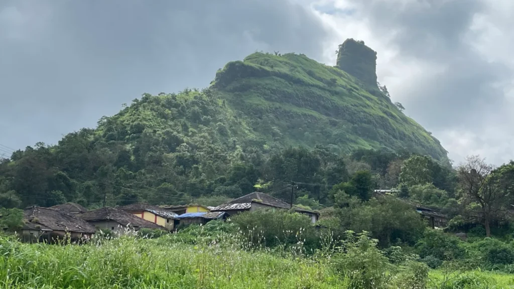
Kothaligad (Peth Fort): The Hidden Watchtower of Karjat Welcome back! If you are looking for a trek that feels like a secret adventure, then Kothaligad is exactly what you need. Also known as Peth Fort because of the small village at its base, this fort is famous for its unique shape and the incredible “funnel” staircase carved inside the rock. It is one of the best treks near Karjat for both beginners and experienced hikers. 1. Introduction & Location Overview Kothaligad is a small but beautiful fort located in the Karjat region of Maharashtra. It stands at a kothaligad fort height of approximately 3,100 feet. The fort is situated near the village of Ambivli and the smaller hamlet of Peth. The location is special because it offers a 360-degree view of the Sahyadri range, including the Bhimashankar and Padargad peaks. Unlike many massive forts, Kothaligad is more of a watchtower, standing tall like a chimney on a flat plateau. 2. Why This Fort Is Famous Kothaligad is most famous for its unique engineering. The top of the fort is a solid rock pinnacle. Instead of walking around it, the ancient builders carved a spiral staircase inside the rock! It feels like you are walking up through a secret chimney to reach the sky. It is also widely popular for the kothaligad fireflies festival. In the weeks before the monsoon starts (usually late May or early June), thousands of fireflies light up the trees around the Peth village and the trek path, making it look like a fairy tale. 3. Detailed History of the Fort The history of Kothaligad is quite interesting. While it is not a huge military stronghold, it served as an important watchtower. Ancient Roots: The caves and carvings at the base suggest the fort has been in use since the 13th century. Maratha Era: Chhatrapati Shivaji Maharaj captured this fort to guard the trade routes in the Konkan. Battles for Control: In 1817, during the war between the Marathas and the British, the fort was briefly captured by the British, then retaken by the Marathas, before finally falling back into British hands. Strategic Role: Because of its height and location, it was used primarily to store ammunition and keep an eye on enemy movements in the Maval and Konkan regions. 4. Architecture & Strategic Importance The architecture of Kothaligad is simple yet very effective. The Cave: At the base of the pinnacle, there is a massive cave (Bhairav Haud) that was used as a granary or for staying during the rains. The Internal Staircase: The rock-cut stairs are protected from wind and rain, allowing soldiers to move up and down even in bad weather. Water Systems: Like most Maratha forts, it has several water tanks carved into the rock to ensure a supply for the soldiers throughout the year. 5. How to Reach the Fort Reaching Kothaligad is quite straightforward: By Train: Take a local train to Karjat Station. By Bus: From Karjat station (East), you can take a State Transport (ST) bus or a shared rickshaw (Tum-Tum) to Ambivli village. By Road: The karjat to kothaligad distance is about 30 km. You can drive your car or bike directly to Ambivli, where there is parking available. Trek Routes: The trek starts from Ambivli, goes through Peth village, and then up to the fort. 6. Trek Information The kothaligad trek is a favorite for many because of its gradual incline. Difficulty: The kothaligad trek difficulty level is Easy to Moderate. Duration: It takes about 2 to 2.5 hours to reach the top from Ambivli. Route: The first part is a wide mud road to Peth village. The second part is a steeper but well-defined path to the caves and the final rock staircase. 7. Entry Fees, Timings & Permissions Entry Fee: Usually, there is no formal entry fee, but sometimes local villagers may collect a small “cleanliness fee” (₹20-₹30). Timings: The fort is open 24/7. However, if you are not doing kothaligad camping, it is best to start by 7:00 AM. Permissions: No special permissions are required for day treks. 8. Best Time to Visit Monsoon (July to September): The best time for greenery, waterfalls, and clouds. Winter (October to February): Best for clear views and a pleasant climb. Pre-Monsoon (May/June): Specifically for the kothaligad fireflies night trek. 9. Things to See on the Fort The Chimney Stairs: The famous internal rock-cut staircase. Bhairav Cave: A large, clean cave near the top with a small temple. Water Tanks: Ancient tanks that still hold water. Cannon: A small old cannon still lies on the fort. Peth Village: A small, friendly village halfway up where you can see the local lifestyle. 10. Things to Do Near the Fort Kothaligad Camping: Many groups offer kothaligad camping experiences near Peth village, complete with local food and bonfires. Solanpada Dam: A beautiful dam located nearby, perfect for a quick visit after the trek. Karjat Markets: Explore the local markets in Karjat for fresh produce and snacks. 11. Safety Risks & Dangerous Areas The Stairs: While the staircase is inside the rock, it can be very slippery during the monsoon. Narrow Path: The final climb up the pinnacle is narrow; avoid pushing or rushing others. Monkeys: Like many forts, monkeys here might try to snatch food from your bags. 12. Safety Precautions Grip: Wear shoes with excellent grip, especially if trekking in the rain. Light: If you are doing a night trek for fireflies, carry a powerful torch. Hydration: Drink plenty of water; there is a climb involved even if it is “easy.” 13. Things to Carry Before Visiting Water: At least 2-3 liters. Food: Snacks or a packed lunch (though you can get food in Peth village). Identity Proof: Always good to carry one. Personal Medicine: Especially for allergies or cuts. 14. Travel Tips Local Food: Try the Pithla Bhakri or Thecha in Peth village; it is delicious and supports the locals. Silence: During the fireflies trek, keep your torch light